Stage 15 OS Map of PCP Stage 16 Stage 17
Stage 16 NEWGALE to SOLVA (20th May 2015)
We caught the #411 bus from St. David’s to Newgale, getting off by the shop on the main road, just before it turns to run parallel to the beach. There’s a shop, a pub and public toilets there.
Going North, the Coast Path leaves the A487 just higher up from the shop, on a blind bend. The path heads steeply uphill to Bryn y Mor headland, giving great views back of the pebbly sweep of Newgale Beach and of the Brandy Brook, flowing along the shoreline then exiting from the base of the cliff through a shingle bank into the sea.
On this South facing hillside we saw the first foxgloves of the summer and clumps of deep blue Sheep’s-bit on either side of the track. This is the first of some six steep climbs on this short section, making it one of the stiffer walks on the Coast Path on St. David’s Peninsula.
At the top of the climb there is a dramatic view looking along the coast ahead, with headlands, islands and small rocks strung out in a succession of parallel lines stretching away to Ramsey Island in the distance. The short cropped grass was blanketed by covering of blue star-shaped spring squill flowers.
A sharp descent into Cwm Mawr follows, the first of several steep sided valleys where small streams flow down into the sea. The geology of the cliffs mixes the sharply defined strata of the northern stages of the peninsula with more boulder-like material here. At sea level there are masses of caves and the occasional natural arch. The headlands are grassy and soft underfoot, ideal for walking but the downs and ups are stony, often with steep stepped sections.
We watched a lone gannet patrolling the cliff edge then suddenly plunge, with a sizeable splash, into the sea. No clear outcome of the dive, though. Closer at hand a small slow worm slithered away as we approached. A continual chorus of LBJs accompanied us, chiff-chaffs, skylarks in profusion, various finches and another unidentifiable one with a black cap.
We crossed another small stream above Porthmynawyd then climbed up above the promontory of Dynas Fach, labelled on the map as an ancient fort, the headland almost cut-off apart from a narrow rocky causeway. (The Welsh name translates as ‘small hillfort’). Archaeologists suggest both Iron Age and Roman use of the site.
Above the next promontory, Pen Dinas, horses were grazing the scrub on land belonging to St. Elvis’ Farm. The village of Upper Solva is visible ahead and seems to be quite close but there are still two or three more steep ascents before you arrive in the Solva valley itself.
The path heads towards St. Elvis Rock, ominous cracks in the earth hinting at the instability of the cliffs here. Then the track veers away from the edge to go behind another headland on a final plunge to the tiny Gwadn beach.
The last short stepped climb is one of the steepest, taking you onto the top of the Gribin (another Iron Age hillfort), a rocky headland with a ridge walk along it, but we chose to follow the Coast Path down through a tree- lined track with bluebells and hart’s tongue ferns growing in profusion on the banks.
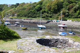
The path emerges on Solva harbour by old lime kilns. It was low tide so we walked along the river mouth to the Harbour Inn for much needed drinks and food. The bus stop for the #400 and #411 buses back to St. David’s is 200m from the pub up the A487 going south from Lower Solva.
The Pembrokeshire Coastal Path is one of the official UK National Trails, running from Amroth to St. Dogmaels, along clifftops, beaches and estuaries. The total length is 300 kilometres (185 miles).
You can download this route to your GPS or mobile phone by clicking on the 'View route..' link on the map below (provided you have registered (free) with ViewRanger
Get Ordnance Survey maps on your website to enhance the service and customer experience.
photos by Michael Beer
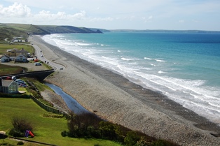 Newgale Beach
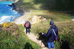 Descent to Cwm Mawr
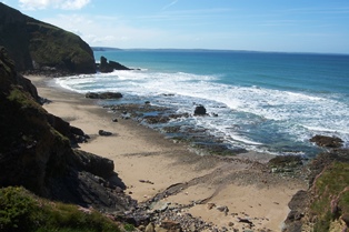 Cwm Bach cliffs and beach
 Porthmynawyd inlet
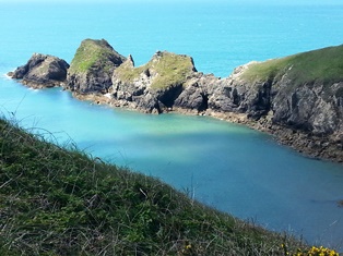
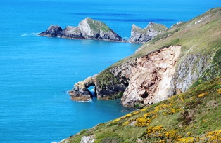 Natural arch at Stacen y Brhenin
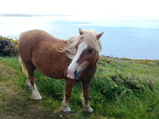 Horse grazing at St. Elvis Farm
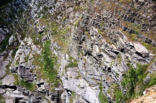 Rock strata at Dinas Head
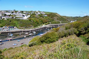 Solva harbour
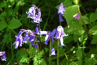 Bluebells
 Limekilns at Solva harbour