Stage 2 OS Map of PCP Stage 2a Stage 3
Use scroll and zoom buttons on map to move around.Stage 2a PENALLY to TENBY (12th October 2014)
This is a very short (about 2 hour) walk although you may want to spend much longer exploring Tenby itself which has much of interest. There is an infrequent train to Penally station (on the line from Swansea to Pembroke Dock) Trains. If there is no convenient train the walk can be turned into a Tenby to Penally round trip by walking along the track which runs from Station Rd. in Tenby between a golf course and train line to Penally.
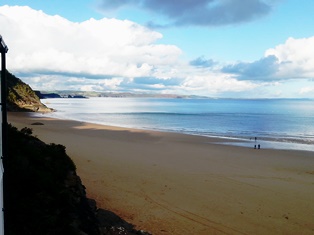
As the train left we were very hospitably offered hot drinks and snacks from a trolley but there was no time to even serve them before we got off 3 minutes later. Penally station has an adjacent tea room and toilets. Go right along the road from the station exit, heading right again in 50m down a track to cross the railway line. The path goes ahead into the golf course. Just before reaching the dunes the path goes right towards the headland of Giltar Point, shortly after turning left at the fence of the rifle range. You arrive on the vast expanse of South Beach stretching some 3km to the foot of Castle Rock at Tenby. The dunes are being eroded and efforts to stabilise them are underway. We walked along the shoreline where flocks of turnstones were busy rushing into the retreating waves then scurrying along the beach as the next wave came in and all the while keeping an eye out for any dogs that came their way. The clifftop terraces of elegant Georgian and Victorian buildings of Tenby are impressive high on the cliffs with Castle Hill off to the right. Just offshore is the squat looking Victorian fort on St. Catherines Island, only an island at high tide. From this angle you can see a natural arch going right through it with daylight at the far end. Walking on firm sand just above the tideline is easy and gives great views of the approach to the town. A zig-zagging ramp takes you up from the beach to the Esplanade. By staying near the cliff edge you pass through the old town walls into the narrow street plan of the medieval town to reach Castle Hill via St. Julian’s St. This promontory is criss-crossed by footpaths. At sea level on the east side is the new lifeboat house right next to the old lifeboat house, now a private residence memorably featured on the TV programme Grand Designs. Higher up the headland is the Victorian bandstand, a Norman tower, part of the original castle keep ( but dwarfed by a memorial statue to Prince Albert). There is also an interesting town museum and art gallery. After exploring Castle Hill head back up St. Julian’s St. and take a right turn down a small alley signposted to the NT Tudor Merchants House, dating from 1470. The steps continue down to meet the coast again immediately above the pretty protected harbour. Turn left to rejoin High St., then left again down Warren St. to return to the train station.
Total distance walked 7.2km (4.5 miles) Ascent 70m Time 2 hours.
The Pembrokeshire Coastal Path is one of the official UK National Trails, running from Amroth to St. Dogmaels, along clifftops, beaches and estuaries. The total length is 300 kilometres (185 miles).
You can download this route to your GPS or mobile phone by clicking on the 'View route..' link on the map below (provided you have registered (free) with ViewRanger
Get Ordnance Survey maps on your website to enhance the service and customer experience.
 Tenby North Beach
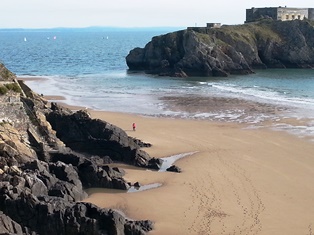 St. Catherine's Fort tidal island
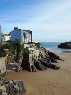 Regency Terrace on the cliff